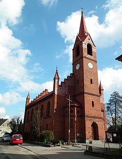
Okonek
Appearance
Okonek | |
|---|---|
 Church of Our Lady of Redemption of Slaves | |
| Coordinates: 53°32′N 16°51′E / 53.533°N 16.850°E | |
| Country | |
| Voivodeship | Greater Poland |
| County | Złotów |
| Gmina | Okonek |
| Town rights | 1754 |
| Area | |
• Total | 6.01 km2 (2.32 sq mi) |
| Population (2010)[1] | |
• Total | 3,855 |
| • Density | 640/km2 (1,700/sq mi) |
| Time zone | UTC+1 (CET) |
| • Summer (DST) | UTC+2 (CEST) |
| Postal code | 64-965 |
| Vehicle registration | PZL |
| National road | |
| Website | http://www.okonek.pl/ |
Okonek [ɔˈkɔnɛk] (German: Ratzebuhr) is a town in Poland, in Złotów County in Greater Poland Voivodeship, with approximately 4,200 inhabitants. Chartered as a town in 1754.
Demographics
[edit]| Year | Pop. | ±% |
|---|---|---|
| 1871 | 2,174 | — |
| 1880 | 2,432 | +11.9% |
| 1890 | 2,298 | −5.5% |
| 1900 | 2,245 | −2.3% |
| 1910 | 2,375 | +5.8% |
| 1925 | 2,611 | +9.9% |
| 1939 | 2,940 | +12.6% |
| 1950 | 2,156 | −26.7% |
| 1960 | 3,153 | +46.2% |
| 2010 | 3,855 | +22.3% |
| Source: [2][1] | ||
References
[edit]- ^ a b Stan i struktura ludności oraz ruch naturalny w przekroju terytorialnym w 2010 r. (PDF) (in Polish). Warszawa: Główny Urząd Statystyczny. 2011. p. 107. Archived from the original (PDF) on 13 November 2011.
- ^ Dokumentacja Geograficzna (in Polish). Vol. 3/4. Warszawa: Instytut Geografii Polskiej Akademii Nauk. 1967. p. 34.


